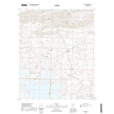
2020 Map of Bismarck
USGS Topo · Published 2020About this map
Bismarck serves as a central hub in this Hot Spring County landscape, situated at the junction of several rural routes and just north of the expansive De Gray Lake. The settlement of Lambert lies to the west, separated by the winding course of Big Hill Cr. The terrain is defined by a series of drainages, including Fourche-a-Loupe Cr and Prairie Bayou, which flow through the northern reaches near Needles Eye Mtn. Local history is anchored by several family and community landmarks, such as Pleasant Hill Cem and Forrest Hill Cem. The southern portion of the map transition into the lake environment, where the Hot Spring County and Clark County line crosses the water. This 2020 survey illustrates the modern road network, including Chicot Trl and Ozark Loop, that connects the various creek valleys and highland ridges.
Find a feature on this map
111 named features on this map. Tap any name to fly to it.
Don’t see what you’re looking for? This feature index may not catch every label — zoom into the map to look around manually.
Map Details
Editions of this 2020 Bismarck Map
This is the sole edition of this map. No revisions or reprints were ever made.
Other maps of this area

1943 · Antoine
USGS Topo · 1:62,500

1955 · Little Rock
USGS Topo · 1:250,000

1956 · Little Rock
USGS Topo · 1:250,000

1959 · Caddo Valley
USGS Topo · 1:24,000

1960 · Little Rock
USGS Topo · 1:250,000

1964 · Little Rock
USGS Topo · 1:250,000

1966 · Pearcy
USGS Topo · 1:24,000

1966 · Hempwallace
USGS Topo · 1:24,000

1966 · De Roche
USGS Topo · 1:24,000
1966 · Point Cedar
USGS Topo · 1:24,000