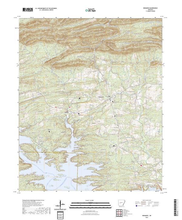
2024 Map of Bismarck
USGS Topo · Published 2024About this map
De Gray Lake dominates the southern landscape of this Arkansas survey, where the waters of the Caddo River meet the Hot Spring County and Clark County line. The terrain transitions from the inundated valleys of the south to the higher elevations of Needles Eye Mtn and the Jack Mountain WMA in the north. This modern snapshot of the area around Bismarck reveals a settlement pattern deeply rooted in local heritage, evidenced by the numerous community burying grounds such as Forest Hill Cem, Marcus Gardens Cem, and Oak Bower Cem. The junction of Lambert remains a focal point for the western rural corridors, while the landscape is defined by the winding paths of Big Hill Creek and De Roche Creek. The presence of several historic church sites, including the Bismarck First Baptist Church Cem, provides a detailed record of the spiritual and social hubs that have anchored this region for generations.
Find a feature on this map
85 named features on this map. Tap any name to fly to it.
Don’t see what you’re looking for? This feature index may not catch every label — zoom into the map to look around manually.
Map Details
Editions of this 2024 Bismarck Map
This is the sole edition of this map. No revisions or reprints were ever made.
Other maps of this area

1943 · Antoine
USGS Topo · 1:62,500

1955 · Little Rock
USGS Topo · 1:250,000

1956 · Little Rock
USGS Topo · 1:250,000

1959 · Caddo Valley
USGS Topo · 1:24,000

1960 · Little Rock
USGS Topo · 1:250,000

1964 · Little Rock
USGS Topo · 1:250,000

1966 · Pearcy
USGS Topo · 1:24,000

1966 · Hempwallace
USGS Topo · 1:24,000

1966 · De Roche
USGS Topo · 1:24,000
1966 · Point Cedar
USGS Topo · 1:24,000