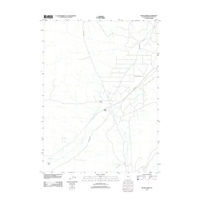
2012 Map of Bitter Creek
USGS Topo · Published 2012About this map
Bitter Creek serves as a central reference point in this corner of Sweetwater County, where the high desert landscape is defined by the ephemeral flow of Bitter Cr and the industrial infrastructure of the Patrick Draw Oil Field. The map reveals a high-density network of resource extraction roads, particularly around the Patrick Draw depression, where numerous unnamed service tracks branch off from Patrick Draw Rd and Co Rd 4-65. This development pattern highlights the significant role of energy production in the local economy during the early 21st century, contrasting with the sparse settlement and open terrain of the surrounding basin. The intersection of these industrial routes with Bitter Creek Rd creates a distinct grid of human activity in an otherwise austere Wyoming environment.
Find a feature on this map
7 named features on this map. Tap any name to fly to it.
Don’t see what you’re looking for? This feature index may not catch every label — zoom into the map to look around manually.
Map Details
Editions of this 2012 Bitter Creek Map
This is the sole edition of this map. No revisions or reprints were ever made.
Other maps of this area

1954 · Rock Springs
USGS Topo · 1:250,000

1958 · Rock Springs
USGS Topo · 1:250,000

1962 · Rock Springs
USGS Topo · 1:250,000

1968 · Bitter Creek NW
USGS Topo · 1:24,000

1968 · Sand Butte Rim NW
USGS Topo · 1:24,000

1968 · Bitter Creek
USGS Topo · 1:24,000

1968 · Black Buttes
USGS Topo · 1:24,000
1968 · Antelope Flats
USGS Topo · 1:24,000

1968 · Bitter Creek NE
USGS Topo · 1:24,000

1970 · Table Rock
USGS Topo · 1:24,000