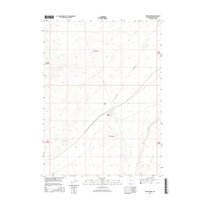
2015 Map of Bitter Creek
USGS Topo · Published 2015About this map
Bitter Creek serves as the central focal point of this Sweetwater County landscape, situated where the high desert drainage meets established transportation routes. The terrain is defined by the winding course of Bitter Cr and the broad expanse of Patrick Draw, a significant geographical feature that shares its name with the local Patrick Draw Rd. This 2015 survey illustrates the modern grid of Sweetwater County roads, including CR-24, which navigate the arid basins and township boundaries like t19n r99w and t18n r99w. The mapping details the intersection of natural watercourses and man-made infrastructure in a region traditionally known for its energy resources and expansive public lands.
Find a feature on this map
11 named features on this map. Tap any name to fly to it.
Don’t see what you’re looking for? This feature index may not catch every label — zoom into the map to look around manually.
Map Details
Editions of this 2015 Bitter Creek Map
This is the sole edition of this map. No revisions or reprints were ever made.
Other maps of this area

1954 · Rock Springs
USGS Topo · 1:250,000

1958 · Rock Springs
USGS Topo · 1:250,000

1962 · Rock Springs
USGS Topo · 1:250,000

1968 · Bitter Creek NW
USGS Topo · 1:24,000

1968 · Sand Butte Rim NW
USGS Topo · 1:24,000

1968 · Bitter Creek
USGS Topo · 1:24,000

1968 · Black Buttes
USGS Topo · 1:24,000
1968 · Antelope Flats
USGS Topo · 1:24,000

1968 · Bitter Creek NE
USGS Topo · 1:24,000

1970 · Table Rock
USGS Topo · 1:24,000