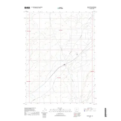
2018 Map of Bitter Creek
USGS Topo · Published 2018About this map
Bitter Creek serves as a central hub of this desert landscape, located where the local rail line and road networks converge. The terrain is defined by the winding course of Bitter Cr and the topographic variations of Patrick Draw, reflecting the arid environment of Sweetwater County. Transportation is a defining feature of the area's development, with Bitter Creek Rd, Patrick Draw Rd, and Co Hwy 24 providing the primary access through the high plains. The map illustrates a section of the American West where geography and infrastructure are closely tied to the watercourses and natural draws that once dictated early travel and settlement routes.
Find a feature on this map
12 named features on this map. Tap any name to fly to it.
Don’t see what you’re looking for? This feature index may not catch every label — zoom into the map to look around manually.
Map Details
Editions of this 2018 Bitter Creek Map
This is the sole edition of this map. No revisions or reprints were ever made.
Other maps of this area

1954 · Rock Springs
USGS Topo · 1:250,000

1958 · Rock Springs
USGS Topo · 1:250,000

1962 · Rock Springs
USGS Topo · 1:250,000

1968 · Bitter Creek NW
USGS Topo · 1:24,000

1968 · Sand Butte Rim NW
USGS Topo · 1:24,000

1968 · Bitter Creek
USGS Topo · 1:24,000

1968 · Black Buttes
USGS Topo · 1:24,000
1968 · Antelope Flats
USGS Topo · 1:24,000

1968 · Bitter Creek NE
USGS Topo · 1:24,000

1970 · Table Rock
USGS Topo · 1:24,000