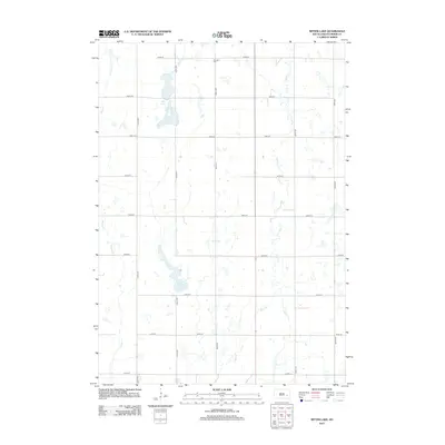
2012 Map of Bitter Lake
USGS Topo · Published 2012About this map
Bitter Lake and the smaller Twin Lakes dominate the prairie depression of this Miner County landscape in 2012. The area is defined by a rigid section-line grid of rural roads, including 425th Ave and 240th St, which trace the agricultural development of the plains. Waterways such as Pooley Cr and Rock Cr meander across the terrain, feeding into the numerous seasonal wetlands and basins that characterize the region's hydrography. Near the northern edge of the map, the Roswell Cem stands as a quiet marker of the local community's history, situated along 234th St. The map reflects a modern South Dakota landscape where the natural drainage patterns of the prairie potholes coexist with a highly structured network of county thoroughfares.
Find a feature on this map
19 named features on this map. Tap any name to fly to it.
Don’t see what you’re looking for? This feature index may not catch every label — zoom into the map to look around manually.
Map Details
Editions of this 2012 Bitter Lake Map
This is the sole edition of this map. No revisions or reprints were ever made.
Other maps of this area

1899 · Alexandria
USGS Topo · 1:125,000

1899 · De Smet
USGS Topo · 1:125,000

1953 · Watertown
USGS Topo · 1:250,000

1955 · Sioux Falls
USGS Topo · 1:250,000

1958 · Sioux Falls
USGS Topo · 1:250,000

1958 · Watertown
USGS Topo · 1:250,000

1971 · Fedora
USGS Topo · 1:24,000

1971 · Howard
USGS Topo · 1:24,000
1972 · Roswell
USGS Topo · 1:24,000
1973 · Morris Lake
USGS Topo · 1:24,000