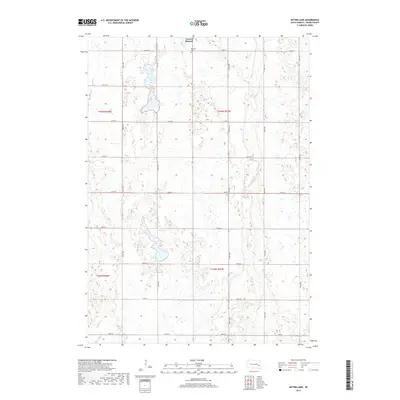
2017 Map of Bitter Lake
USGS Topo · Published 2017About this map
The Town of Roswell serves as the primary settlement within this section of Miner County, situated near the northern boundary. The landscape is defined by its glacial prairie hydrology, featuring a network of intermittent waterways and depressions such as Bitter Lake, Twin Lakes, and the Burke Slough. These water bodies are connected by seasonal drainages including Pooley Cr and Rock Cr, which navigate the township divisions of T106N and T105N. The rural character is reinforced by the presence of the Roswell Cem just south of the town center. The area is gridded by a precise network of section-line roads, such as 234th St and 427th Ave, illustrating the enduring influence of the Public Land Survey System on South Dakota's agricultural development.
Find a feature on this map
25 named features on this map. Tap any name to fly to it.
Don’t see what you’re looking for? This feature index may not catch every label — zoom into the map to look around manually.
Map Details
Editions of this 2017 Bitter Lake Map
This is the sole edition of this map. No revisions or reprints were ever made.
Other maps of this area

1899 · Alexandria
USGS Topo · 1:125,000

1899 · De Smet
USGS Topo · 1:125,000

1953 · Watertown
USGS Topo · 1:250,000

1955 · Sioux Falls
USGS Topo · 1:250,000

1958 · Sioux Falls
USGS Topo · 1:250,000

1958 · Watertown
USGS Topo · 1:250,000

1971 · Fedora
USGS Topo · 1:24,000

1971 · Howard
USGS Topo · 1:24,000
1972 · Roswell
USGS Topo · 1:24,000
1973 · Morris Lake
USGS Topo · 1:24,000