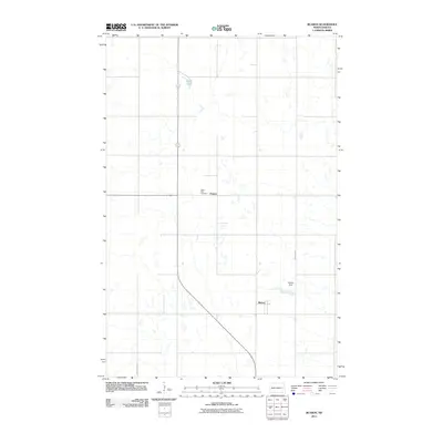
2011 Map of Blabon
USGS Topo · Published 2011About this map
Blabon and Pickert anchor this rural Steele County landscape, illustrating the enduring agricultural grid of eastern North Dakota. The area's settlement history is marked by the Saint Petri Cemetery, located just north of Pickert, serving as a significant point of interest for genealogical research in the region. The terrain is characterized by numerous small glacial depressions and wetlands typical of the prairie pothole region, with Lynch Lake and the man-made Blabon Dam providing the primary water features. Transportation in this section of the state relies on a network of sectional roads, including County Hwy 8A and County Rd 4, which connect these small prairie communities and outlying farmsteads.
Find a feature on this map
7 named features on this map. Tap any name to fly to it.
Don’t see what you’re looking for? This feature index may not catch every label — zoom into the map to look around manually.
Map Details
Editions of this 2011 Blabon Map
This is the sole edition of this map. No revisions or reprints were ever made.
Other maps of this area

1952 · Grand Forks
USGS Topo · 1:250,000

1956 · Grand Forks
USGS Topo · 1:250,000

1966 · Grand Forks
USGS Topo · 1:250,000

1967 · Blabon
USGS Topo · 1:24,000

1967 · Finley
USGS Topo · 1:24,000
1967 · Luverne
USGS Topo · 1:24,000
1967 · Sharon
USGS Topo · 1:24,000
1967 · Luverne NW
USGS Topo · 1:24,000

1967 · Luverne SE
USGS Topo · 1:24,000

1968 · Sherbrooke
USGS Topo · 1:24,000