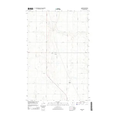
2014 Map of Blabon
USGS Topo · Published 2014About this map
Maple River meanders through the central corridor of this Steele County landscape, defining the local topography between the small settlements of Pickert and Blabon. In this rural North Dakota landscape, the intersection of section-line roads and state infrastructure is anchored by Nd-32, which cuts diagonally across the gridded prairie. For those researching local heritage, the Saint Petri Cem stands as a significant landmark just south of Pickert, while Lynch Lake provides a natural break in the agricultural plains to the north. The map illustrates a contemporary pattern of land use where historic place names persist alongside modern road designations like 127th Ave NE and Center St, reflecting the enduring structure of these rural communities.
Find a feature on this map
27 named features on this map. Tap any name to fly to it.
Don’t see what you’re looking for? This feature index may not catch every label — zoom into the map to look around manually.
Map Details
Editions of this 2014 Blabon Map
This is the sole edition of this map. No revisions or reprints were ever made.
Other maps of this area

1952 · Grand Forks
USGS Topo · 1:250,000

1956 · Grand Forks
USGS Topo · 1:250,000

1966 · Grand Forks
USGS Topo · 1:250,000

1967 · Blabon
USGS Topo · 1:24,000

1967 · Finley
USGS Topo · 1:24,000
1967 · Luverne
USGS Topo · 1:24,000
1967 · Sharon
USGS Topo · 1:24,000
1967 · Luverne NW
USGS Topo · 1:24,000

1967 · Luverne SE
USGS Topo · 1:24,000

1968 · Sherbrooke
USGS Topo · 1:24,000