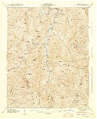
1947 Map of Black Brothers
USGS Topo · Published 1947About this map
Cane River winds through this high-elevation terrain of Yancey County, where isolated mountain communities like Pensacola and Murchison sit tucked into the narrow valleys. The landscape is defined by its extreme relief, climbing from the riverbanks up to the heights of Mt Mitchell State Park, where a lookout tower and Camp Alice overlook the Black Mountains. This 1946 field examination captures the area as a mix of protected wilderness and small-scale mountain habitation, evidenced by a series of family burial grounds including Burleson Cem, Penland Cem, and Wheeler Cem. The presence of a toll gate along the river road near Eakota highlights the historic difficulty of travel through this part of the Pisgah National Forest. Waterfalls such as Mitchell Falls and Walker Falls dot the numerous branches and forks that drain the ridges, including the appropriately named Point Misery and Bearwallow Stand Ridge.
Find a feature on this map
92 named features on this map. Tap any name to fly to it.
Don’t see what you’re looking for? This feature index may not catch every label — zoom into the map to look around manually.
Map Details
Editions of this 1947 Black Brothers Map
2 editions found
Other maps of this area

1900 · Mount Mitchell
USGS Topo · 1:125,000

1902 · Mount Mitchell
USGS Topo · 1:125,000

1934 · Micaville
USGS Topo · 1:24,000

1934 · Parts Of Celo And Black Brothers
USGS Topo · 1:24,000

1934 · Parts Of Old Fort and Montreat
USGS Topo · 1:24,000

1935 · Montreat
USGS Topo · 1:24,000

1935 · Black Brothers
USGS Topo · 1:24,000

1935 · Burnsville
USGS Topo · 1:24,000

1935 · Bald Creek
USGS Topo · 1:24,000

1935 · Barnardsville
USGS Topo · 1:24,000