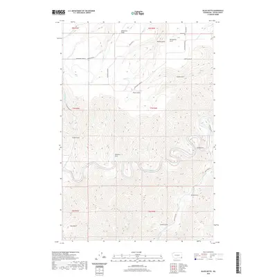
2020 Map of Black Butte
USGS Topo · Published 2020About this map
Grande Ronde River carves a deep path through this corner of Asotin County, defining a landscape of steep gulches and high ridges. The waterway makes a dramatic loop at The Narrows, where the terrain drops sharply from the surrounding plateaus. To the north, Weissenfels Ridge and Montgomery Ridge Rd provide access to the uplands, overlooking deep cuts like Matheny Gulch and Fisher Gulch. This 2020 survey captures the rugged topography of the Blue Mountains foothills, where traditional ranching and timber access routes like Shumaker Grade Rd and Joseph Creek Rd follow the natural contours of the land. Evidence of early settlers remains at the Craige Cem in the north, while the southern portion is dominated by the impressive depths of Joseph Canyon and the prominent volcanic landmark of Black Butte.
Find a feature on this map
37 named features on this map. Tap any name to fly to it.
Don’t see what you’re looking for? This feature index may not catch every label — zoom into the map to look around manually.
Map Details
Editions of this 2020 Black Butte Map
This is the sole edition of this map. No revisions or reprints were ever made.
Other maps of this area

1944 · Anatone
USGS Topo · 1:62,500

1946 · Limekiln Rapids
USGS Topo · 1:62,500

1946 · Anatone
USGS Topo · 1:62,500

1955 · Pullman
USGS Topo · 1:250,000

1955 · Grangeville
USGS Topo · 1:250,000

1958 · Pullman
USGS Topo · 1:250,000

1959 · Grangeville
USGS Topo · 1:250,000

1963 · Jim Creek Butte
USGS Topo · 1:24,000
1967 · Paradise
USGS Topo · 1:24,000
1967 · Teepee Butte
USGS Topo · 1:24,000