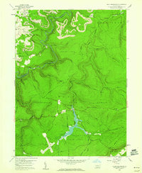
1959 Map of Black Moshannon
USGS Topo · Published 1960About this map
Moshannon State Forest dominates this Central Pennsylvania landscape, where the plateau is deeply incised by the winding course of Moshannon Creek. During the late 1950s, the region was a mix of recreational development and heavy industry. At the heart of the sheet, the Black Moshannon Dam holds back the waters within Black Moshannon State Park, surrounded by a network of drainage including Benner Run and Black Moshannon Creek.
Find a feature on this map
52 named features on this map. Tap any name to fly to it.
Don’t see what you’re looking for? This feature index may not catch every label — zoom into the map to look around manually.
Map Details
Editions of this 1959 Black Moshannon Map
3 editions found
Other maps of this area

1908 · Bellefonte
USGS Topo · 1:62,500

1909 · Bellefonte
USGS Topo · 1:62,500

1922 · Philipsburg
USGS Topo · 1:62,500

1928 · Snow Shoe
USGS Topo · 1:48,000

1929 · Karthaus
USGS Topo · 1:62,500

1931 · Show Shoe
USGS Topo · 1:62,500

1932 · Karthaus
USGS Topo · 1:62,500

1939 · Philipsburg
USGS Topo · 1:62,500

1943 · Lewistown
USGS Topo · 1:125,000

1945 · Philipsburg
USGS Topo · 1:62,500
Featured Places
- Rush Township, PA
- Beaver Mills, Rush Township
- Viaduct, Cooper Township
- Huston Township, PA
- Gorton, Snow Shoe Township