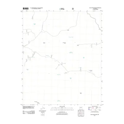
2011 Map of Black Mountain
USGS Topo · Published 2011About this map
Black Mountain Lookout stands as the primary vantage point in this high-elevation landscape within Catron County. The terrain is characterized by a sophisticated network of water management features essential for ranching and survival in this arid environment, including Perdido Tank, Buckhorn Tank, and the uniquely named Trap Corral Tank. These catchment points are distributed across the high country, often near landmarks like Birthday Windmill and Houghton Windmill. Remote transportation infrastructure is represented by the Beaverhead Airstrip, while Loco Mountain Rd provides the main overland passage through the area. The geography is deeply incised by natural drainages such as Cooney Canyon and Wolf Hollow Canyon, which drop away from the prominent Beaver Points.
Find a feature on this map
21 named features on this map. Tap any name to fly to it.
Don’t see what you’re looking for? This feature index may not catch every label — zoom into the map to look around manually.
Map Details
Editions of this 2011 Black Mountain Map
This is the sole edition of this map. No revisions or reprints were ever made.
Other maps of this area

1911 · Alum Mountain
USGS Topo · 1:125,000

1913 · Alum Mountain
USGS Topo · 1:125,000

1918 · Pelona
USGS Topo · 1:125,000

1954 · Clifton
USGS Topo · 1:250,000

1957 · Clifton
USGS Topo · 1:250,000

1958 · Clifton
USGS Topo · 1:250,000

1962 · Clifton
USGS Topo · 1:250,000
1965 · Canyon Creek Mountains
USGS Topo · 1:24,000
1965 · Woodland Park
USGS Topo · 1:24,000
1967 · Wall Lake
USGS Topo · 1:24,000