1967 Map of Wall Lake
USGS Topo · Published 1971About this map
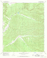
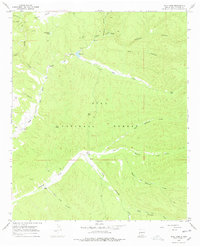
Wall Lake serves as a central hydrological landmark in this high-altitude section of the Gila National Forest, where the complex drainage systems of the Mogollon Mountains converge. The map illustrates a landscape shaped by water and ranching, with the East Fork Gila River and several branches of Diamond Creek carving deep canyons through the volcanic terrain. Long-established cattle operations are documented by the presence of the DD Ranch, Steeple U Ranch, and Link Ranch, alongside numerous livestock watering features like Undertaker Tank and Knife Tank. Human activity is further evidenced by a small Mine and scattered prospects near Whitewater Creek, reflecting the mineral exploration that often accompanied early homesteading in Catron County. Significant relief is shown across Kemp Mesa and through the labyrinthine passages of Whitetail Canyon.
Find a feature on this map
36 named features on this map. Tap any name to fly to it.
Don’t see what you’re looking for? This feature index may not catch every label — zoom into the map to look around manually.
Map Details
Editions of this 1967 Wall Lake Map
2 editions found
Other maps of this area

1911 · Alum Mountain
USGS Topo · 1:125,000

1913 · Alum Mountain
USGS Topo · 1:125,000
1949 · Lookout Mountain
USGS Topo · 1:62,500

1954 · Tularosa
USGS Topo · 1:250,000

1954 · Clifton
USGS Topo · 1:250,000

1957 · Clifton
USGS Topo · 1:250,000

1958 · Clifton
USGS Topo · 1:250,000

1958 · Tularosa
USGS Topo · 1:250,000

1962 · Clifton
USGS Topo · 1:250,000
1963 · Bonner Canyon
USGS Topo · 1:24,000