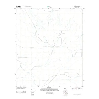
2013 Map of Black Mountains
USGS Topo · Published 2013About this map
Black Mountains define the high ground of this West Texas landscape, where life and activity are dictated by the scarce presence of water. In this arid reach of Hudspeth County, the map records a critical network of man-made water catchments, including Quatro Julio Tank, McAdoo Tank, and Black Mountain Tank. These features, along with the natural drainage of Court Draw, provide a clear picture of the pastoral infrastructure required for ranching in the Chihuahuan Desert. The sparse road network and scattered tanks like Flat Bottom Tank and Bond Tank suggest a remote, large-acreage land use pattern typical of the region in the early 21st century, where human footprints are concentrated around these vital water sources.
Find a feature on this map
8 named features on this map. Tap any name to fly to it.
Don’t see what you’re looking for? This feature index may not catch every label — zoom into the map to look around manually.
Map Details
Editions of this 2013 Black Mountains Map
This is the sole edition of this map. No revisions or reprints were ever made.
Other maps of this area

1895 · Sierra Blanca
USGS Topo · 1:125,000

1948 · Triple Hill
USGS Topo · 1:62,500

1951 · Red Hills
USGS Topo · 1:62,500

1954 · Van Horn
USGS Topo · 1:250,000

1955 · Black Mountains
USGS Topo · 1:62,500

1958 · Van Horn
USGS Topo · 1:250,000

1973 · Norton Mesa
USGS Topo · 1:24,000

1973 · Sneed Mountain NE
USGS Topo · 1:24,000
1979 · Black Hills
USGS Topo · 1:24,000
1984 · Babb Canyon
USGS Topo · 1:24,000