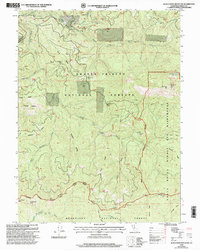
1998 Map of Black Rock Mountain
USGS Topo · Published 2003About this map
Martin Cabin and several historic cabin sites anchor this rugged high-altitude landscape where the Shasta-Trinity National Forests meet the Mendocino National Forest. The map documents a transition in wilderness management, showing the Eel River Middle Bolly Yolla Wilderness boundary stretching across prominent landmarks like Black Rock Mtn and its associated lookout. The terrain is defined by the headwaters of the South Fork Trinity River and the North Fk Middle Fk Eel River, revealing the complex drainage systems of the Northern California Coast Ranges. Local history is preserved through labels for remote camps and clearings like Bearwallow Camp and Penney Glades, while the Humboldt Trail and Mad River Road provide the primary historical access through these mountain ridges.
Find a feature on this map
49 named features on this map. Tap any name to fly to it.
Don’t see what you’re looking for? This feature index may not catch every label — zoom into the map to look around manually.
Map Details
Editions of this 1998 Black Rock Mountain Map
This is the sole edition of this map. No revisions or reprints were ever made.
Other maps of this area

1890 · Red Bluff
USGS Topo · 1:250,000

1894 · Red Bluff
USGS Topo · 1:250,000

1931 · Hoaglin
USGS Topo · 1:96,000

1935 · Hoaglin
USGS Topo · 1:125,000

1951 · Chanchelulla Peak
USGS Topo · 1:62,500

1953 · Blackrock Mtn
USGS Topo · 1:62,500

1954 · Dubakella Mtn
USGS Topo · 1:62,500

1954 · Blackrock Mtn
USGS Topo · 1:62,500

1954 · Yolla Bolly
USGS Topo · 1:62,500

1958 · Redding
USGS Topo · 1:250,000