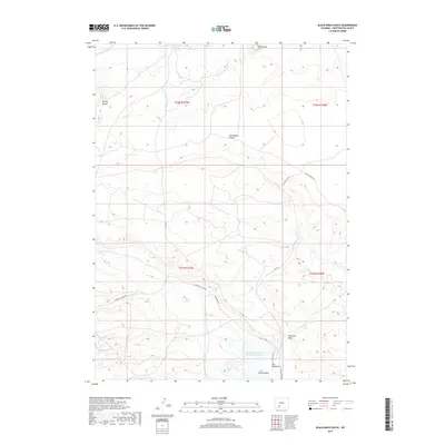
2017 Map of Black Rock South
USGS Topo · Published 2017About this map
The Continental Divide traverses this high-altitude landscape in Sweetwater County, marking the hydraulic backbone of the region. This 2017 survey illustrates a stark, arid environment dominated by drainage patterns like Potash Wash and Ninemile Wash, which flow toward the Jim Bridger Project Evaporation Pond in the southern portion of the quadrangle. Significant elevation markers include Spring Butte and the landmark Black Rock, providing critical orientation in a territory defined by its topographic relief rather than dense settlement. The road network, including the Superior Cutoff Rd and Nine Mile Rd, reflects the area's role in supporting industrial or resource-based transport. Natural water features like Rador Springs and Black Rock Cr appear as vital landmarks within this high-desert terrain near The Meadows.
Find a feature on this map
17 named features on this map. Tap any name to fly to it.
Don’t see what you’re looking for? This feature index may not catch every label — zoom into the map to look around manually.
Map Details
Editions of this 2017 Black Rock South Map
This is the sole edition of this map. No revisions or reprints were ever made.
Other maps of this area

1954 · Rock Springs
USGS Topo · 1:250,000

1958 · Rock Springs
USGS Topo · 1:250,000

1958 · Twelvemile Well
USGS Topo · 1:62,500

1958 · Superior
USGS Topo · 1:62,500

1962 · Rock Springs
USGS Topo · 1:250,000

1968 · Bitter Creek NW
USGS Topo · 1:24,000

1968 · Point Of Rocks
USGS Topo · 1:24,000
1968 · Thayer Junction
USGS Topo · 1:24,000
1980 · Red Desert Basin
USGS Topo · 1:100,000
1986 · Black Rock Flat West
USGS Topo · 1:24,000