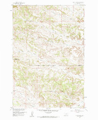
1958 Map of Black Spring
USGS Topo · Published 1985About this map
The Northern Cheyenne Indian Reservation Boundary divides the landscape where Rosebud and Big Horn counties meet. This terrain, mapped for the Missouri River Basin development program in the late 1950s, is defined by an intricate network of drainage systems feeding into Rosebud Creek. The northern portion is dominated by the many branches of Cottonwood Creek, including Little Cottonwood Creek and the South Fork Cottonwood Creek. Isolated water sources such as Lynch Spring, Indian Coulee Spring, and the titular Black Spring provided essential hubs for cattle and wildlife in an otherwise arid environment. Evidence of movement across the ridgelines is preserved in several Jeep Trails that navigate the coulees, tracing routes through Lynch Coulee and alongside Water Holes Creek.
Find a feature on this map
16 named features on this map. Tap any name to fly to it.
Don’t see what you’re looking for? This feature index may not catch every label — zoom into the map to look around manually.
Map Details
Editions of this 1958 Black Spring Map
2 editions found
Other maps of this area

1954 · Hardin
USGS Topo · 1:250,000

1957 · Hardin
USGS Topo · 1:250,000

1958 · Hardin
USGS Topo · 1:250,000

1958 · Chalky Point
USGS Topo · 1:24,000

1958 · Painted Hill
USGS Topo · 1:24,000

1958 · Jimtown
USGS Topo · 1:24,000

1958 · Black Spring
USGS Topo · 1:24,000

1958 · Busby
USGS Topo · 1:24,000

1958 · Lame Deer
USGS Topo · 1:24,000

1971 · Colstrip SW
USGS Topo · 1:24,000