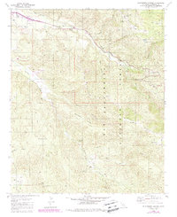
1982 Map of Blackburn Canyon
USGS Topo · Published 1988About this map
San Bernardino National Forest dominates this landscape, where the confluence of the North Fork and South Fork San Jacinto River meets near the Cranston FS Station. The terrain is defined by prominent elevations such as Rouse Hill and Red Mountain, the latter of which is marked by a Lookout Tower and Radio Facility. The drainage patterns are clearly visible, tracing the path of Bautista Creek through the rugged Blackburn Canyon and past Hixon Flat.
Find a feature on this map
31 named features on this map. Tap any name to fly to it.
Don’t see what you’re looking for? This feature index may not catch every label — zoom into the map to look around manually.
Map Details
Editions of this 1982 Blackburn Canyon Map
4 editions found
Other maps of this area

1901 · Southern California Sheet No. 1
USGS Topo · 1:250,000

1901 · San Jacinto
USGS Topo · 1:125,000

1904 · Southern California Sheet No. 1
USGS Topo · 1:250,000

1940 · Palm Springs
USGS Topo · 1:62,500

1940 · Hemet Reservoir
USGS Topo · 1:62,500

1942 · Banning
USGS Topo · 1:62,500

1942 · Hemet Reservoir
USGS Topo · 1:62,500

1942 · Hemet
USGS Topo · 1:62,500

1943 · Hemet
USGS Topo · 1:62,500

1943 · Banning
USGS Topo · 1:62,500