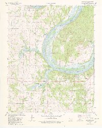
1978 Map of Blackburn
USGS Topo · Published 1978About this map
The Arkansas River serves as the dominant geographical and political divide on this map, marking the Osage Indian Reservation Boundary between Osage and Pawnee counties. This late-1970s landscape is defined by the energy industry and water management, featuring extensive oil fields and numerous individual oil wells scattered across the uplands. The small settlement of Blackburn sits north of the river, near the Blackburn Cem, while the southern portion of the quadrangle shows the impact of the Cleveland Reservoir on the local drainage system.
Find a feature on this map
35 named features on this map. Tap any name to fly to it.
Don’t see what you’re looking for? This feature index may not catch every label — zoom into the map to look around manually.
Map Details
Editions of this 1978 Blackburn Map
2 editions found
Other maps of this area

1912 · Hominy
USGS Topo · 1:125,000

1915 · Hominy
USGS Topo · 1:125,000

1915 · Hominy
USGS Topo · 1:62,500

1929 · Yale
USGS Topo · 1:62,500

1929 · Skedee
USGS Topo · 1:62,500

1931 · Skedee
USGS Topo · 1:62,500

1932 · Yale
USGS Topo · 1:62,500

1955 · Enid
USGS Topo · 1:250,000

1958 · Enid
USGS Topo · 1:250,000

1966 · Cleveland
USGS Topo · 1:24,000