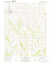
1953 Map of Blackburn
USGS Topo · Published 1979About this map
Blackburn stands as a central settlement along the Gulf Mobile and Ohio railroad corridor during the mid-20th century. This agricultural landscape on the border of Lafayette and Saline counties is defined by its rural infrastructure, featuring a dense network of country schools and churches that served the outlying farming community. Significant landmarks such as Pisgah Ch and Salt Pond Ch are joined by several local educational sites including Mt Zion Sch, Kennedy Sch, and Forbes Sch. The terrain is drained by several waterways, most notably Salt Pond Creek, Jordan Creek, and the East Fork. The presence of multiple family and community burial grounds, such as Blackburn Cem, Allen Cem, and Gross Cem, provides valuable points of interest for those studying the genealogical history of the Elmwood and Salt Pond townships.
Find a feature on this map
21 named features on this map. Tap any name to fly to it.
Don’t see what you’re looking for? This feature index may not catch every label — zoom into the map to look around manually.
Map Details
Editions of this 1953 Blackburn Map
2 editions found
Other maps of this area

1885 · Warrensburg
USGS Topo · 1:125,000

1887 · Sedalia
USGS Topo · 1:125,000

1887 · Warrensburg
USGS Topo · 1:125,000

1889 · Lexington
USGS Topo · 1:125,000

1890 · Marshall
USGS Topo · 1:125,000

1892 · Marshall
USGS Topo · 1:125,000

1894 · Sedalia
USGS Topo · 1:125,000

1894 · Warrensburg
USGS Topo · 1:125,000

1901 · Marshall
USGS Topo · 1:125,000

1917 · Knobnoster
USGS Topo · 1:62,500