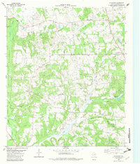
1982 Map of Blackfoot
USGS Topo · Published 1982About this map
Catfish Creek and its many tributaries define the wooded landscape of northern Anderson County in the early 1980s. The western edge of the sheet is dominated by the Engeling State Wildlife Management Area, a preserved expanse of post oak savannah and wetlands. Small rural communities like Blackfoot and Springfield are linked by a network of roads that wind between numerous family-named watercourses, including Box Creek and Otter Creek. Local spiritual and family history is preserved at sites such as Friendship Ch and Providence Cem, while several Oil Wells indicate the active mineral extraction typical of this Texas region. To the east, the terrain shifts near Camp Bette Perot, where Beaver Creek and Holly Spring Branch converge, illustrating the complex drainage patterns of the Trinity River basin.
Find a feature on this map
25 named features on this map. Tap any name to fly to it.
Don’t see what you’re looking for? This feature index may not catch every label — zoom into the map to look around manually.
Map Details
Editions of this 1982 Blackfoot Map
This is the sole edition of this map. No revisions or reprints were ever made.
Other maps of this area

1949 · Palestine
USGS Topo · 1:62,500

1949 · Frankston
USGS Topo · 1:62,500

1949 · Athens
USGS Topo · 1:62,500

1949 · Tennessee Colony
USGS Topo · 1:62,500

1950 · Athens
USGS Topo · 1:62,500

1950 · Palestine
USGS Topo · 1:62,500

1950 · Frankston
USGS Topo · 1:62,500

1950 · Tennessee Colony
USGS Topo · 1:62,500

1953 · Palestine
USGS Topo · 1:250,000

1956 · Tyler
USGS Topo · 1:250,000