
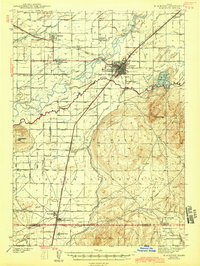
1943 Map of Blackfoot
USGS Topo · Published 1943About this map
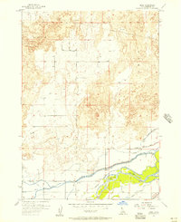
The Snake River and Blackfoot River converge in this 1940s survey of southeastern Idaho, illustrating a landscape defined by an extensive network of irrigation infrastructure and indigenous land. The Fort Hall Indian Reservation occupies the southern half of the sheet, featuring the Indian Agency, the Indian School, and the Ross Fork Indian Sch. The region's agricultural dependency is evident through a complex system of canals and ditches, such as the Aberdeen-Springfield Canal and the Peoples Canal, which draw from the river systems to support settlements like Moreland, Groveland, and Wapello.
Find a feature on this map
79 named features on this map. Tap any name to fly to it.
Don’t see what you’re looking for? This feature index may not catch every label — zoom into the map to look around manually.
Map Details
Editions of this 1943 Blackfoot Map
2 editions found
Other maps of this area

1934 · Michaud
USGS Topo · 1:62,500

1937 · Pocatello
USGS Topo · 1:48,000

1937 · Michaud
USGS Topo · 1:62,500

1940 · Blackfoot
USGS Topo · 1:62,500

1944 · Pocatello
USGS Topo · 1:62,500

1954 · Pocatello
USGS Topo · 1:250,000
1955 · Baldy Knoll
USGS Topo · 1:24,000
1955 · Lincoln Creek
USGS Topo · 1:24,000
1955 · Rockford
USGS Topo · 1:24,000
1955 · Rose
USGS Topo · 1:24,000