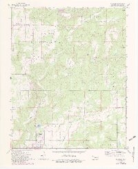
1972 Map of Blackgum
USGS Topo · Published 1983About this map
Blackgum and the surrounding Cookson Hills region of Sequoyah County are defined by a landscape of prominent peaks and winding creek valleys. The terrain is marked by significant elevations like Chuculate Mountain and Anderson Mountain, which overlook the complex drainage of Vian Creek and Red Bird Smith Creek. In the southern portion of the quadrangle, the community of Vian is situated near Vian Lake, where a Gaging Station and Picnic Area indicate a focus on local water management and recreation.
Find a feature on this map
36 named features on this map. Tap any name to fly to it.
Don’t see what you’re looking for? This feature index may not catch every label — zoom into the map to look around manually.
Map Details
Editions of this 1972 Blackgum Map
4 editions found
Other maps of this area

1898 · Tahlequah
USGS Topo · 1:125,000

1900 · Sansbois
USGS Topo · 1:125,000

1900 · Sallisaw
USGS Topo · 1:125,000

1901 · Muscogee
USGS Topo · 1:125,000

1901 · Tahlequah
USGS Topo · 1:125,000

1905 · Muscogee
USGS Topo · 1:125,000

1905 · Tahlequah
USGS Topo · 1:125,000

1909 · Sans Bois
USGS Topo · 1:125,000

1911 · Sallisaw
USGS Topo · 1:125,000

1911 · Sansbois
USGS Topo · 1:125,000