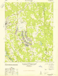
1950 Map of Blackstone
USGS Topo · Published 1950About this map
Blackstone Army Air Base and the expansive Camp Pickett Military Reservation dominate this mid-century landscape at the meeting of Nottoway, Dinwiddie, and Brunswick counties. The post-war military infrastructure is highly detailed, featuring a stadium, amphitheater, and specialized training areas like the Cherry Tree Combat Range and an infiltration course. The town of Blackstone proper serves as the regional hub, connected by the Norfolk and Western railroad and supporting local institutions such as the Nottoway Training School and a ball park. Surrounding the base, the rural character remains evident through family-centric landmarks like Jones Church, Spring Hill Church, and Tree Church. Significant water features, including Birchin Lake and the Nottoway Reservoir, underscore the geographic shifts in the Virginia countryside as it balanced civilian life with large-scale defense installations.
Find a feature on this map
44 named features on this map. Tap any name to fly to it.
Don’t see what you’re looking for? This feature index may not catch every label — zoom into the map to look around manually.
Map Details
Editions of this 1950 Blackstone Map
This is the sole edition of this map. No revisions or reprints were ever made.
Other maps of this area

1907 · Norfolk
USGS Topo · 1:125,000

1907 · Yorktown
USGS Topo · 1:62,500

1907 · Hampton
USGS Topo · 1:62,500

1919 · Smithfield
USGS Topo · 1:62,500

1921 · Newport News
USGS Topo · 1:62,500

1943 · Yorktown
USGS Topo · 1:62,500

1943 · Richmond
USGS Topo · 1:250,000

1944 · Windsor
USGS Topo · 1:31,680

1944 · Morrison
USGS Topo · 1:24,000

1944 · Smithfield
USGS Topo · 1:24,000