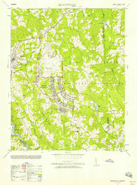
1951 Map of Blackstone
USGS Topo · Published 1958About this map
Blackstone Army Air Base and the expansive Camp Pickett Military Reservation dominate this landscape, reflecting the intensive military mobilization of the mid-20th century. The town of Blackstone serves as the regional anchor, where the Norfolk and Western railroad intersects with local life at the Nottoway Training School and various civic landmarks like the Ball park and Cemetery.
Find a feature on this map
53 named features on this map. Tap any name to fly to it.
Don’t see what you’re looking for? This feature index may not catch every label — zoom into the map to look around manually.
Map Details
Editions of this 1951 Blackstone Map
This is the sole edition of this map. No revisions or reprints were ever made.
Other maps of this area

1907 · Norfolk
USGS Topo · 1:125,000

1907 · Yorktown
USGS Topo · 1:62,500

1907 · Hampton
USGS Topo · 1:62,500

1919 · Smithfield
USGS Topo · 1:62,500

1921 · Newport News
USGS Topo · 1:62,500

1943 · Yorktown
USGS Topo · 1:62,500

1943 · Richmond
USGS Topo · 1:250,000

1944 · Windsor
USGS Topo · 1:31,680

1944 · Morrison
USGS Topo · 1:24,000

1944 · Smithfield
USGS Topo · 1:24,000