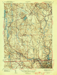
1944 Map of Blackstone
USGS Topo · Published 1944About this map
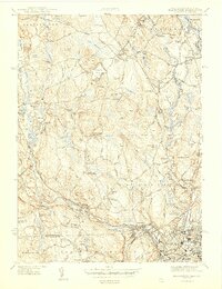
The Blackstone River and the Mumford River define this industrial and agricultural landscape as it appeared during the 1940s. Centered on the Massachusetts and Rhode Island border, the area is crisscrossed by the New York New Haven and Hartford Railroad, which served the manufacturing villages of Millville, Blackstone, and Waterford. The map reveals a high density of civic and religious institutions, including the Chestnut Hills Meeting House, Friends Ch, and the L'hospice St Antoine in North Smithfield.
Find a feature on this map
84 named features on this map. Tap any name to fly to it.
Don’t see what you’re looking for? This feature index may not catch every label — zoom into the map to look around manually.
Map Details
Editions of this 1944 Blackstone Map
5 editions found
Other maps of this area

1886 · Blackstone
USGS Topo · 1:62,500

1887 · Franklin
USGS Topo · 1:62,500

1887 · Providence
USGS Topo · 1:62,500

1889 · Providence
USGS Topo · 1:62,500

1889 · Blackstone
USGS Topo · 1:62,500

1889 · Franklin
USGS Topo · 1:62,500

1889 · Burrillville
USGS Topo · 1:62,500

1893 · Franklin
USGS Topo · 1:62,500

1893 · Blackstone
USGS Topo · 1:62,500

1894 · Burrillville
USGS Topo · 1:62,500