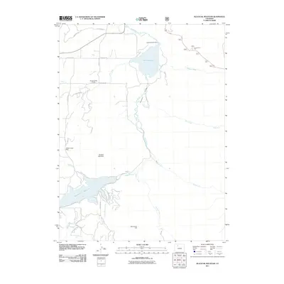
2011 Map of Blacktail Mountain
USGS Topo · Published 2011About this map
Stagecoach Reservoir and Lake Catamount dominate the high-elevation landscape of this Routt County region, where the Yampa River winds through the valley floor. The hydrology of the area is heavily managed, marked by the Lake Catamount Dam and a network of irrigation features like the Suttle Ditch. Notable topographic landmarks include Blacktail Mountain and Woodchuck Hill, while Yellow Jacket Pass provides a key transit point through the varying elevations. The map reveals a transition from the structured recreational areas around Ferndale Picnic Area and the Pleasant Valley Airport to the more dispersed backcountry road systems. Numerous named tributaries, such as Sarvis Creek, Morrison Creek, and Dry Creek, feed into the primary river system, illustrating the complex drainage patterns essential to this Colorado mountain environment.
Find a feature on this map
45 named features on this map. Tap any name to fly to it.
Don’t see what you’re looking for? This feature index may not catch every label — zoom into the map to look around manually.
Map Details
Editions of this 2011 Blacktail Mountain Map
This is the sole edition of this map. No revisions or reprints were ever made.
Other maps of this area

1954 · Craig
USGS Topo · 1:250,000

1956 · Storm Mountain
USGS Topo · 1:24,000

1956 · Walton Peak
USGS Topo · 1:24,000

1956 · Gore Pass
USGS Topo · 1:62,500

1956 · Rabbit Ears Peak
USGS Topo · 1:62,500

1957 · Craig
USGS Topo · 1:250,000

1958 · Craig
USGS Topo · 1:250,000

1960 · Craig
USGS Topo · 1:250,000

1962 · Craig
USGS Topo · 1:250,000

1964 · Craig
USGS Topo · 1:250,000