
1967 Map of Blackwater Lake SW
USGS Topo · Published 1982About this map
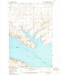
Lake Sakakawea dominates the landscape of this 1960s survey, marking a transformative period for the Missouri River valley along the McLean and Mercer county line. The map captures the expansive waters of Nishu Bay and the shoreline management practices of the era, visible in the Nishu Public Use Area and the Beaver Creek State Game Management Area.
Find a feature on this map
11 named features on this map. Tap any name to fly to it.
Don’t see what you’re looking for? This feature index may not catch every label — zoom into the map to look around manually.
Map Details
Editions of this 1967 Blackwater Lake SW Map
2 editions found
Historical Maps of White Shield Through Time
253 maps found

1949 Turtle Creek
McLean County, ND

1956 Blackwater Lake
McLean County, ND

1956 Blackwater Lake NW
McLean County, ND

1956 Blue Hill
McLean County, ND

1956 Douglas West
McLean County, ND

1956 Emmet
McLean County, ND

1956 Emmet NE
McLean County, ND

1956 Makoti SW
McLean County, ND

1956 Roseglen
McLean County, ND

1961 Lake Nettie
McLean County, ND

1961 Pelican Lake
McLean County, ND

1961 Peterson Lake
McLean County, ND

1961 Turtle Creek NE
McLean County, ND

1961 Turtle Creek NW
McLean County, ND

1961 Turtle Creek SE
McLean County, ND

1961 Turtle Creek SW
McLean County, ND

1961 Washburn NE
McLean County, ND

1966 Sanger
McLean County, ND

1967 Blackwater Lake SE
McLean County, ND
1967 Blackwater Lake SW
McLean County, ND

1967 Emmet SE
McLean County, ND

1967 Emmet SW
McLean County, ND

1967 New Town SE
McLean County, ND

1967 Parshall SE
McLean County, ND

1967 Parshall SW
McLean County, ND

1967 Raub
McLean County, ND

1967 Raub NW
McLean County, ND

1967 Stanton SE
McLean County, ND

1967 Washburn SW
McLean County, ND

1972 Garrison Dam North
McLean County, ND

1972 Riverdale North
McLean County, ND

1972 Riverdale South
McLean County, ND

1974 Benedict SE
McLean County, ND

1974 Benedict SW
McLean County, ND

1974 Coleharbor NE
McLean County, ND

1974 Coleharbor NW
McLean County, ND

1974 Garrison NE
McLean County, ND

1974 Garrison NW
McLean County, ND

1974 Kongsberg SE
McLean County, ND

1974 Kongsberg SW
McLean County, ND

1974 Pelican Lake NW
McLean County, ND

1974 Turtle Lake NE
McLean County, ND

1974 Turtle Lake NW
McLean County, ND

1980 Douglas East
McLean County, ND

1980 Turtle Creek SE
McLean County, ND

1981 Alkali Lake
McLean County, ND

1981 Benedict SW
McLean County, ND

1981 Coleharbor NE
McLean County, ND

1981 Coleharbor NW
McLean County, ND

1981 Garrison NE
McLean County, ND

1981 Horseshoe Valley
McLean County, ND

1981 Kongsberg
McLean County, ND

1981 Long Lake
McLean County, ND

2011 Alkali Lake
McLean County, ND

2011 Benedict SW
McLean County, ND

2011 Blackwater Lake
McLean County, ND

2011 Blackwater Lake NW
McLean County, ND

2011 Blackwater Lake SE
McLean County, ND

2011 Blackwater Lake SW
McLean County, ND

2011 Blue Hill
McLean County, ND

2011 Coleharbor NE
McLean County, ND

2011 Coleharbor NW
McLean County, ND

2011 Douglas East
McLean County, ND

2011 Douglas West
McLean County, ND

2011 Emmet
McLean County, ND

2011 Emmet NE
McLean County, ND

2011 Emmet SE
McLean County, ND

2011 Emmet SW
McLean County, ND

2011 Garrison Dam North
McLean County, ND

2011 Garrison NE
McLean County, ND

2011 Horseshoe Valley
McLean County, ND

2011 Kongsberg
McLean County, ND

2011 Lake Nettie
McLean County, ND

2011 Long Lake
McLean County, ND

2011 Makoti SW
McLean County, ND

2011 New Town SE
McLean County, ND

2011 Parshall SE
McLean County, ND

2011 Parshall SW
McLean County, ND

2011 Pelican Lake
McLean County, ND

2011 Peterson Lake
McLean County, ND

2011 Raub
McLean County, ND

2011 Raub NW
McLean County, ND

2011 Riverdale North
McLean County, ND

2011 Riverdale South
McLean County, ND

2011 Roseglen
McLean County, ND

2011 Sanger
McLean County, ND

2011 Stanton SE
McLean County, ND

2011 Turtle Creek NE
McLean County, ND

2011 Turtle Creek NW
McLean County, ND

2011 Turtle Creek SE
McLean County, ND

2011 Turtle Creek SW
McLean County, ND

2011 Washburn NE
McLean County, ND

2011 Washburn SW
McLean County, ND

2014 Alkali Lake
McLean County, ND

2014 Benedict SW
McLean County, ND

2014 Blackwater Lake
McLean County, ND

2014 Blackwater Lake NW
McLean County, ND

2014 Blackwater Lake SE
McLean County, ND

2014 Blackwater Lake SW
McLean County, ND

2014 Blue Hill
McLean County, ND

2014 Coleharbor NE
McLean County, ND

2014 Coleharbor NW
McLean County, ND

2014 Douglas East
McLean County, ND

2014 Douglas West
McLean County, ND

2014 Emmet
McLean County, ND

2014 Emmet NE
McLean County, ND

2014 Emmet SE
McLean County, ND

2014 Emmet SW
McLean County, ND

2014 Garrison Dam North
McLean County, ND

2014 Garrison NE
McLean County, ND

2014 Horseshoe Valley
McLean County, ND

2014 Kongsberg
McLean County, ND

2014 Lake Nettie
McLean County, ND

2014 Long Lake
McLean County, ND

2014 Makoti SW
McLean County, ND

2014 New Town SE
McLean County, ND

2014 Parshall SE
McLean County, ND

2014 Parshall SW
McLean County, ND

2014 Pelican Lake
McLean County, ND

2014 Peterson Lake
McLean County, ND

2014 Raub
McLean County, ND

2014 Raub NW
McLean County, ND

2014 Riverdale North
McLean County, ND

2014 Riverdale South
McLean County, ND

2014 Roseglen
McLean County, ND

2014 Sanger
McLean County, ND

2014 Stanton SE
McLean County, ND

2014 Turtle Creek NE
McLean County, ND

2014 Turtle Creek NW
McLean County, ND

2014 Turtle Creek SE
McLean County, ND

2014 Turtle Creek SW
McLean County, ND

2014 Washburn NE
McLean County, ND

2014 Washburn SW
McLean County, ND

2017 Benedict SW
McLean County, ND

2017 Blue Hill
McLean County, ND

2017 Emmet
McLean County, ND

2017 Emmet NE
McLean County, ND

2017 Emmet SE
McLean County, ND

2017 Emmet SW
McLean County, ND

2017 Garrison Dam North
McLean County, ND

2017 Makoti SW
McLean County, ND

2017 Turtle Creek SW
McLean County, ND

2017 Washburn NE
McLean County, ND

2018 Alkali Lake
McLean County, ND

2018 Blackwater Lake
McLean County, ND

2018 Blackwater Lake NW
McLean County, ND

2018 Blackwater Lake SE
McLean County, ND

2018 Blackwater Lake SW
McLean County, ND

2018 Coleharbor NE
McLean County, ND

2018 Coleharbor NW
McLean County, ND

2018 Douglas East
McLean County, ND

2018 Douglas West
McLean County, ND

2018 Garrison NE
McLean County, ND

2018 Horseshoe Valley
McLean County, ND

2018 Kongsberg
McLean County, ND

2018 Lake Nettie
McLean County, ND

2018 Long Lake
McLean County, ND

2018 New Town SE
McLean County, ND

2018 Parshall SE
McLean County, ND

2018 Parshall SW
McLean County, ND

2018 Pelican Lake
McLean County, ND

2018 Peterson Lake
McLean County, ND

2018 Raub
McLean County, ND

2018 Raub NW
McLean County, ND

2018 Riverdale North
McLean County, ND

2018 Riverdale South
McLean County, ND

2018 Roseglen
McLean County, ND

2018 Sanger
McLean County, ND

2018 Stanton SE
McLean County, ND

2018 Turtle Creek NE
McLean County, ND

2018 Turtle Creek NW
McLean County, ND

2018 Turtle Creek SE
McLean County, ND

2018 Washburn SW
McLean County, ND

2020 Alkali Lake
McLean County, ND

2020 Benedict SW
McLean County, ND

2020 Blackwater Lake
McLean County, ND

2020 Blackwater Lake NW
McLean County, ND

2020 Blackwater Lake SE
McLean County, ND

2020 Blackwater Lake SW
McLean County, ND

2020 Blue Hill
McLean County, ND

2020 Coleharbor NE
McLean County, ND

2020 Coleharbor NW
McLean County, ND

2020 Douglas East
McLean County, ND

2020 Douglas West
McLean County, ND

2020 Emmet
McLean County, ND

2020 Emmet NE
McLean County, ND

2020 Emmet SE
McLean County, ND

2020 Emmet SW
McLean County, ND

2020 Garrison Dam North
McLean County, ND

2020 Garrison NE
McLean County, ND

2020 Horseshoe Valley
McLean County, ND

2020 Kongsberg
McLean County, ND

2020 Lake Nettie
McLean County, ND

2020 Long Lake
McLean County, ND

2020 Makoti SW
McLean County, ND

2020 New Town SE
McLean County, ND

2020 Parshall SE
McLean County, ND

2020 Parshall SW
McLean County, ND

2020 Pelican Lake
McLean County, ND

2020 Peterson Lake
McLean County, ND

2020 Raub
McLean County, ND

2020 Raub NW
McLean County, ND

2020 Riverdale North
McLean County, ND

2020 Riverdale South
McLean County, ND

2020 Roseglen
McLean County, ND

2020 Sanger
McLean County, ND

2020 Stanton SE
McLean County, ND

2020 Turtle Creek NE
McLean County, ND

2020 Turtle Creek NW
McLean County, ND

2020 Turtle Creek SE
McLean County, ND

2020 Turtle Creek SW
McLean County, ND

2020 Washburn NE
McLean County, ND

2020 Washburn SW
McLean County, ND

2024 Alkali Lake
McLean County, ND

2024 Benedict SW
McLean County, ND

2024 Blackwater Lake
McLean County, ND

2024 Blackwater Lake NW
McLean County, ND

2024 Blackwater Lake SE
McLean County, ND

2024 Blackwater Lake SW
McLean County, ND

2024 Blue Hill
McLean County, ND

2024 Coleharbor NE
McLean County, ND

2024 Coleharbor NW
McLean County, ND

2024 Douglas East
McLean County, ND

2024 Douglas West
McLean County, ND

2024 Emmet
McLean County, ND

2024 Emmet NE
McLean County, ND

2024 Emmet SE
McLean County, ND

2024 Emmet SW
McLean County, ND

2024 Garrison Dam North
McLean County, ND

2024 Garrison NE
McLean County, ND

2024 Horseshoe Valley
McLean County, ND

2024 Kongsberg
McLean County, ND

2024 Lake Nettie
McLean County, ND

2024 Long Lake
McLean County, ND

2024 Makoti SW
McLean County, ND

2024 New Town SE
McLean County, ND

2024 Parshall SE
McLean County, ND

2024 Parshall SW
McLean County, ND

2024 Pelican Lake
McLean County, ND

2024 Peterson Lake
McLean County, ND

2024 Raub
McLean County, ND

2024 Raub NW
McLean County, ND

2024 Riverdale North
McLean County, ND

2024 Riverdale South
McLean County, ND

2024 Roseglen
McLean County, ND

2024 Sanger
McLean County, ND

2024 Stanton SE
McLean County, ND

2024 Turtle Creek NE
McLean County, ND

2024 Turtle Creek NW
McLean County, ND

2024 Turtle Creek SE
McLean County, ND

2024 Turtle Creek SW
McLean County, ND

2024 Washburn NE
McLean County, ND

2024 Washburn SW
McLean County, ND