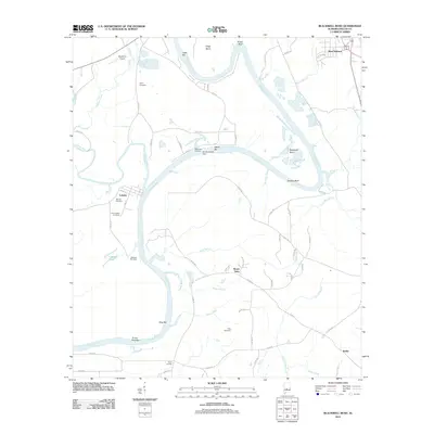
2011 Map of Blackwell Bend
USGS Topo · Published 2011About this map
Blackwell Bend and the sinuous loops of the Alabama River dominate this Dallas County landscape, where river geography and family legacy intersect. The waterway is punctuated by numerous bars and landings, including Cade Bar, Kings Landing, and the Turkey Ford Bar. The convergence of the Cahaba River with the Alabama occurs near the old Cahaba Cemetery, a site of significant local heritage. Several small settlements anchor the rural road network, notably West Selmont in the northeast and Berlin in the southeast. For genealogists, the map is particularly detailed regarding burial sites, pinpointing the Henry Cemetery, Matthew Cemetery, and King Cemetery across various creek drainages. The presence of Skyharbor Airport and the R L Mcdowell Dam near McDowell Landing reflects the 21st-century infrastructure managing these ancient waterways, while names like Hatcher Bluff and Kings Bluff define the dramatic riverbanks.
Find a feature on this map
71 named features on this map. Tap any name to fly to it.
Don’t see what you’re looking for? This feature index may not catch every label — zoom into the map to look around manually.
Map Details
Editions of this 2011 Blackwell Bend Map
This is the sole edition of this map. No revisions or reprints were ever made.
Other maps of this area

1953 · Montgomery
USGS Topo · 1:250,000

1956 · Montgomery
USGS Topo · 1:250,000

1957 · Montgomery
USGS Topo · 1:250,000

1957 · Carlowville
USGS Topo · 1:62,500

1957 · Benton
USGS Topo · 1:62,500

1957 · Braggs
USGS Topo · 1:62,500

1958 · Selma
USGS Topo · 1:62,500

1958 · Selma
USGS Topo · 1:24,000

1975 · Selma NW
USGS Topo · 1:24,000

1975 · Selma SE
USGS Topo · 1:24,000