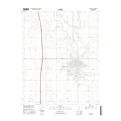
2016 Map of Blackwell
USGS Topo · Published 2016About this map
Blackwell serves as the focal point of this North Central Oklahoma landscape, showing its organized street grid and residential expansion in the mid-2010s. The city is bisected by major thoroughfares such as W Doolin Ave and the central W Dewey Ave, which lead into the surrounding agricultural sections. On the outskirts, the Earl Henry Airport and the Blackwell Cem represent key local infrastructure and historical landmarks for the community. The surrounding terrain is defined by a dendritic network of seasonal waterways, including Dry Cr, Doe Cr, and the winding Stink Cr to the west. These creeks carve subtle relief into the prairie, influencing the placement of rural section roads like W Brake Rd and E0100 Rd. To the northeast, the land is marked by the courses of Bitter Cr and Scatter Cr, illustrating the drainage patterns vital to the region's ranching and farming history.
Find a feature on this map
89 named features on this map. Tap any name to fly to it.
Don’t see what you’re looking for? This feature index may not catch every label — zoom into the map to look around manually.
Map Details
Editions of this 2016 Blackwell Map
This is the sole edition of this map. No revisions or reprints were ever made.
Other maps of this area

1955 · Enid
USGS Topo · 1:250,000

1958 · Enid
USGS Topo · 1:250,000

1967 · Braman
USGS Topo · 1:24,000

1968 · Ponca City NW
USGS Topo · 1:24,000

1968 · Eddy
USGS Topo · 1:24,000

1968 · Blackwell NW
USGS Topo · 1:24,000

1968 · Nardin
USGS Topo · 1:24,000

1968 · Tonkawa
USGS Topo · 1:24,000

1968 · Blackwell
USGS Topo · 1:24,000
1968 · Newkirk SW
USGS Topo · 1:24,000