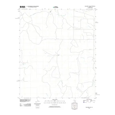
2010 Map of Blackwell SW
USGS Topo · Published 2010About this map
Whiteside Ranch and White Hall Ranch stand as prominent landmarks in this western Texas landscape, reflecting the established ranching traditions of Nolan County. This 2010 survey details a region defined by its complex drainage network, where seasonal waterways such as Antelope Creek and Bouzier Creek carve through the terrain. The map provides a clear look at the rural road system, from the paved F.M. 1170 to a web of local routes including Co RD 314 and Hamilton Rd. These roads often follow the natural contours of the land, connecting remote ranch properties with the surrounding county. The prominence of named watercourses like Mountain Creek and Messbox Creek underscores the importance of every drainage basin in this arid environment, making this an essential record for tracing property boundaries and land use in the early 21st century.
Find a feature on this map
18 named features on this map. Tap any name to fly to it.
Don’t see what you’re looking for? This feature index may not catch every label — zoom into the map to look around manually.
Map Details
Editions of this 2010 Blackwell SW Map
This is the sole edition of this map. No revisions or reprints were ever made.
Other maps of this area

1891 · Hayrick
USGS Topo · 1:125,000

1893 · Sweetwater
USGS Topo · 1:125,000

1894 · Hayrick
USGS Topo · 1:125,000

1921 · Bronte
USGS Topo · 1:31,680

1954 · Big Spring
USGS Topo · 1:250,000

1954 · San Angelo
USGS Topo · 1:250,000

1958 · San Angelo
USGS Topo · 1:250,000

1958 · Big Spring
USGS Topo · 1:250,000
1961 · Bronte
USGS Topo · 1:24,000

1962 · Edith
USGS Topo · 1:24,000