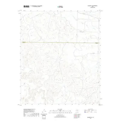
2019 Map of Blackwell SW
USGS Topo · Published 2019About this map
The boundary between Nolan Co and Coke Co bisects this stretch of the Texas ranching country, where a network of ephemeral drainage systems carves through the landscape. This 2019 survey documents the intricate topography surrounding Antelope Creek in the north and the southward-flowing Mountain Creek and Messbox Creek. The map shows a transition from the plateaus of the north toward more dissected terrain in the south. Transportation is defined by rural corridors such as FM 1170 and a series of county roads including Co RD 314 and Co RD 268, which provide access to the various canyons and draws. Named family routes like Hamilton Road and Ross Road indicate the established landholdings and property lines that have shaped this portion of West Texas for generations.
Find a feature on this map
17 named features on this map. Tap any name to fly to it.
Don’t see what you’re looking for? This feature index may not catch every label — zoom into the map to look around manually.
Map Details
Editions of this 2019 Blackwell SW Map
This is the sole edition of this map. No revisions or reprints were ever made.
Other maps of this area

1891 · Hayrick
USGS Topo · 1:125,000

1893 · Sweetwater
USGS Topo · 1:125,000

1894 · Hayrick
USGS Topo · 1:125,000

1921 · Bronte
USGS Topo · 1:31,680

1954 · Big Spring
USGS Topo · 1:250,000

1954 · San Angelo
USGS Topo · 1:250,000

1958 · San Angelo
USGS Topo · 1:250,000

1958 · Big Spring
USGS Topo · 1:250,000
1961 · Bronte
USGS Topo · 1:24,000

1962 · Edith
USGS Topo · 1:24,000