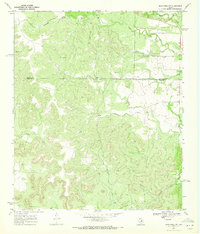
1969 Map of Blackwell SW
USGS Topo · Published 1972About this map
White Hat Ranch and Whiteside Ranch anchor this landscape along the border of Nolan and Coke counties. The area is defined by a dense network of watercourses, including the westward-flowing Antelope Creek and the southern drainage of Mountain Creek. Settlement is sparse, with the locality of Henry appearing on the eastern edge, while the land use reflects a mix of traditional ranching and mid-century industrial activity.
Find a feature on this map
13 named features on this map. Tap any name to fly to it.
Don’t see what you’re looking for? This feature index may not catch every label — zoom into the map to look around manually.
Map Details
Editions of this 1969 Blackwell SW Map
2 editions found
Other maps of this area

1891 · Hayrick
USGS Topo · 1:125,000

1893 · Sweetwater
USGS Topo · 1:125,000

1894 · Hayrick
USGS Topo · 1:125,000

1921 · Bronte
USGS Topo · 1:31,680

1954 · Big Spring
USGS Topo · 1:250,000

1954 · San Angelo
USGS Topo · 1:250,000

1958 · San Angelo
USGS Topo · 1:250,000

1958 · Big Spring
USGS Topo · 1:250,000
1961 · Bronte
USGS Topo · 1:24,000

1962 · Edith
USGS Topo · 1:24,000