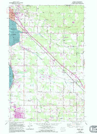
1952 Map of Blaine
USGS Topo · Published 1994About this map
The Canada United States border defines the northern edge of this coastal landscape, where Peace Arch State Park marks the gateway between nations at Blaine. The town's layout is shaped by its maritime and rail connections, with the Burlington Northern line and Portal Way running southeast toward Custer. To the south, the industrial presence of an Oil Refinery near Brown Road contrasts with the surrounding rural character and drainage systems of Dakota Creek and California Creek.
Find a feature on this map
57 named features on this map. Tap any name to fly to it.
Don’t see what you’re looking for? This feature index may not catch every label — zoom into the map to look around manually.
Map Details
Editions of this 1952 Blaine Map
4 editions found
Other maps of this area

1907 · Blaine
USGS Topo · 1:62,500

1952 · Bertrand Creek
USGS Topo · 1:24,000

1952 · Birch Point
USGS Topo · 1:24,000

1952 · Ferndale
USGS Topo · 1:24,000

1952 · Lummi Bay
USGS Topo · 1:24,000

1952 · Blaine
USGS Topo · 1:24,000

1952 · Blaine
USGS Topo · 1:62,500

1957 · Victoria
USGS Topo · 1:250,000

1975 · Bellingham
USGS Topo · 1:100,000
1997 · Lummi Bay
USGS Topo · 1:24,000