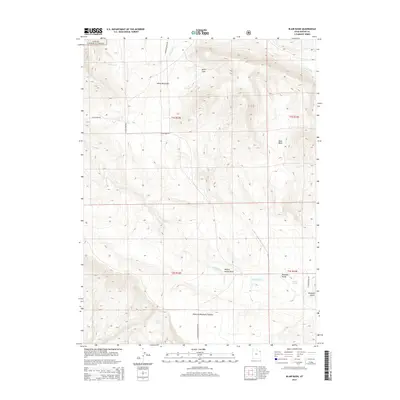
2014 Map of Blair Basin
USGS Topo · Published 2014About this map
Ashley National Forest dominates the high-elevation landscape of north-central Uintah County, where the southern slopes of the Uinta Mountains meet the high tablelands. The terrain is defined by dramatic elevation changes, dropping from the forested heights of Betts Cove toward the expansive Diamond Mountain Plateau. This 2014 survey reveals a rugged interior managed for natural resources, where water sources like Diamond Spring and Squaw Spring were vital for the high-altitude ranching and grazing operations that historically utilized these mountain basins. A network of primitive routes, including N Diamond Mountain Hwy and E Limestone Rd, provide access across the plateau. The complex hydrology of the region is evident in the path of Jones Hole Cr and the presence of the Calder Ditch, reflecting the ongoing importance of water management in Utah's high desert mountain country.
Find a feature on this map
24 named features on this map. Tap any name to fly to it.
Don’t see what you’re looking for? This feature index may not catch every label — zoom into the map to look around manually.
Map Details
Editions of this 2014 Blair Basin Map
This is the sole edition of this map. No revisions or reprints were ever made.
Other maps of this area

1885 · Ashley
USGS Topo · 1:250,000

1950 · Burnt Cabin Gorge
USGS Topo · 1:24,000

1950 · Blair Basin
USGS Topo · 1:24,000

1952 · Warren Draw
USGS Topo · 1:24,000

1954 · Vernal
USGS Topo · 1:250,000

1955 · Island Park
USGS Topo · 1:24,000

1958 · Vernal
USGS Topo · 1:250,000

1960 · Vernal
USGS Topo · 1:250,000
1965 · Donkey Flat
USGS Topo · 1:24,000
1966 · Jensen Ridge
USGS Topo · 1:24,000