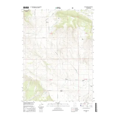
2017 Map of Blair Basin
USGS Topo · Published 2017About this map
Ashley National Forest and the high country of the Uinta Mountains define the northern reaches of this Uintah County landscape. The terrain is characterized by a series of dramatic geographic depressions and elevated landforms, including Blair Basin and the expansive Diamond Mountain Plateau. Water resources are central to the geography here, with seasonal drainages such as Simons Cr and Cow Cr cutting through the slopes, while isolated reliable sources like Squaw Spring and Diamond Spring provided essential points of contact for early land use. This map records the intricate network of remote mountain transit, showing routes such as Davenport Draw Rd, Browns Park Rd, and Pot Creek Loop that navigate the ridges and coves. The presence of the Calder Ditch indicates the historical efforts to manage and divert water through this arid high-elevation environment.
Find a feature on this map
28 named features on this map. Tap any name to fly to it.
Don’t see what you’re looking for? This feature index may not catch every label — zoom into the map to look around manually.
Map Details
Editions of this 2017 Blair Basin Map
This is the sole edition of this map. No revisions or reprints were ever made.
Other maps of this area

1885 · Ashley
USGS Topo · 1:250,000

1950 · Burnt Cabin Gorge
USGS Topo · 1:24,000

1950 · Blair Basin
USGS Topo · 1:24,000

1952 · Warren Draw
USGS Topo · 1:24,000

1954 · Vernal
USGS Topo · 1:250,000

1955 · Island Park
USGS Topo · 1:24,000

1958 · Vernal
USGS Topo · 1:250,000

1960 · Vernal
USGS Topo · 1:250,000
1965 · Donkey Flat
USGS Topo · 1:24,000
1966 · Jensen Ridge
USGS Topo · 1:24,000