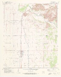
1971 Map of Blair
USGS Topo · Published 1973About this map
Blair sits as a central rail point in southwestern Oklahoma, where the Atchison Topeka and Santa Fe railroad corridor dictates the local geography. The landscape transitions from the agricultural plains surrounding the town to the dramatic granite outcroppings of Quartz Mountain State Park in the northeast. This area is defined by the convergence of the North Fork Red River and the Elm Fork Red River, creating a complex network of canyons and peaks such as Byrd Mountain and King Mountain. The map reveals a highly engineered water management system, with numerous siphons and canals extending from the river toward the smaller settlements like City View. For the local historian, the map preserves the exact layout of the Blair Cem and identifies geological landmarks like Cement Gap and the shifting sands along the riverbanks, illustrating the intersection of human infrastructure and the dynamic river environment.
Find a feature on this map
23 named features on this map. Tap any name to fly to it.
Don’t see what you’re looking for? This feature index may not catch every label — zoom into the map to look around manually.
Map Details
Editions of this 1971 Blair Map
2 editions found
Other maps of this area

1955 · Lawton
USGS Topo · 1:250,000

1964 · Martha
USGS Topo · 1:24,000

1964 · Altus
USGS Topo · 1:24,000

1964 · Lone Wolf
USGS Topo · 1:24,000

1964 · Warren
USGS Topo · 1:24,000

1964 · Headrick
USGS Topo · 1:24,000

1971 · Blair
USGS Topo · 1:24,000

1971 · Granite
USGS Topo · 1:24,000

1971 · Hester
USGS Topo · 1:24,000

1971 · Lake Altus
USGS Topo · 1:24,000