
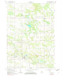
1964 Map of Blanchard
USGS Topo · Published 1965About this map
Blanchard and Millbrook anchor the southern portion of this mid-1960s study, situated along the Chesapeake and Ohio railroad line. The landscape is defined by the transition between active rail infrastructure and an old railroad grade further north, which traces an earlier transportation path through Broomfield and Wheatland townships. Water plays a central role in the local economy and geography, evidenced by the Blanchard Millpond, Babcocks Pond, and the winding course of the Pine River.
Find a feature on this map
38 named features on this map. Tap any name to fly to it.
Don’t see what you’re looking for? This feature index may not catch every label — zoom into the map to look around manually.
Map Details
Editions of this 1964 Blanchard Map
2 editions found
Other maps of this area

1916 · Mount Pleasant
USGS Topo · 1:62,500

1919 · Mount Pleasant
USGS Topo · 1:62,500

1943 · Mount Pleasant
USGS Topo · 1:62,500

1954 · Midland
USGS Topo · 1:250,000

1958 · Midland
USGS Topo · 1:250,000

1959 · Midland
USGS Topo · 1:250,000

1964 · Edmore
USGS Topo · 1:24,000

1964 · Six Lakes
USGS Topo · 1:24,000

1964 · Mecosta NW
USGS Topo · 1:24,000

1964 · Mecosta
USGS Topo · 1:24,000