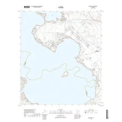
2019 Map of Blanchard
USGS Topo · Published 2019About this map
Lake Livingston dominates this Polk County landscape, its expansive waters defining the geography and shoreline development of the late 2010s. The settlement of Blanchard sits along the northern shore, while West Livingston serves as a secondary hub to the southeast. This survey illustrates a dense network of lakeside residential roads, including those at Indian Hill, which snake through the timbered terrain and along the various inlets formed by Jennings Br and W Tempe Cr. The inclusion of the Livingston Municipal Airport and the sprawling water-focused subdivisions suggests a region shaped by both its aviation infrastructure and its identity as a recreational retreat. To the south, the county line between San Jacinto and Polk follows the meandering course of the Trinity River channel beneath the lake's surface, passing the prominent Pine Island in the center of the reservoir.
Find a feature on this map
119 named features on this map. Tap any name to fly to it.
Don’t see what you’re looking for? This feature index may not catch every label — zoom into the map to look around manually.
Map Details
Editions of this 2019 Blanchard Map
This is the sole edition of this map. No revisions or reprints were ever made.
Other maps of this area

1954 · Beaumont
USGS Topo · 1:250,000

1955 · New Willard
USGS Topo · 1:62,500

1957 · Beaumont
USGS Topo · 1:250,000

1958 · Livingston
USGS Topo · 1:62,500

1960 · Blanchard
USGS Topo · 1:24,000

1960 · Carlisle
USGS Topo · 1:24,000

1960 · Stephen Creek
USGS Topo · 1:24,000

1960 · Camilla
USGS Topo · 1:24,000

1960 · Coldspring
USGS Topo · 1:24,000

1961 · Onalaska
USGS Topo · 1:24,000