
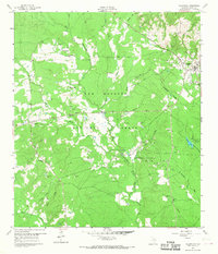
1960 Map of Coldspring
USGS Topo · Published 1962About this map
The East Fork San Jacinto River winds through this 1960s landscape, illustrating the balance between extraction and conservation in San Jacinto County. Large swaths of the Sam Houston National Forest dominate the terrain, surrounding the county seat of Coldspring. The map documents a landscape transitioning from traditional agriculture and timber to mid-century petroleum development, as evidenced by the Coldspring Oil Field and Coline Oil Field. Local history and genealogy are well-represented by numerous family-named landmarks including the Evergreen Cem, Laurel Hill Ch, and Liberty Hill. Physical remnants of earlier infrastructure are still visible, such as the Old Railroad Grade cutting through the western woods. For recreation, the Double Lake Recreation Area provides a established focal point near Tarkington Bayou.
Find a feature on this map
37 named features on this map. Tap any name to fly to it.
Don’t see what you’re looking for? This feature index may not catch every label — zoom into the map to look around manually.
Map Details
Editions of this 1960 Coldspring Map
3 editions found

Other maps of this area

1954 · Beaumont
USGS Topo · 1:250,000

1957 · Beaumont
USGS Topo · 1:250,000

1958 · Westcott
USGS Topo · 1:24,000

1958 · Bear Creek
USGS Topo · 1:24,000

1959 · Conroe NE
USGS Topo · 1:24,000

1960 · Blanchard
USGS Topo · 1:24,000

1960 · Maynard
USGS Topo · 1:24,000

1960 · Stephen Creek
USGS Topo · 1:24,000

1960 · Camilla
USGS Topo · 1:24,000

1961 · Oakhurst
USGS Topo · 1:24,000