
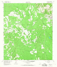
1960 Map of Coldspring
USGS Topo · Published 1978About this map
Sam Houston National Forest defines the wooded character of this San Jacinto County landscape as it appeared in the mid-20th century. The settlement of Coldspring serves as a focal point, surrounded by a network of smaller communities including Evergreen, Laurel Hill, and Spring Hill. This map reveals an economy driven by timber and extraction, evidenced by the Coldspring Oil Field and the Coline Oil Field, alongside numerous scattered oil wells.
Find a feature on this map
44 named features on this map. Tap any name to fly to it.
Don’t see what you’re looking for? This feature index may not catch every label — zoom into the map to look around manually.
Map Details
Editions of this 1960 Coldspring Map
3 editions found
Other maps of this area

1954 · Beaumont
USGS Topo · 1:250,000

1957 · Beaumont
USGS Topo · 1:250,000

1958 · Westcott
USGS Topo · 1:24,000

1958 · Bear Creek
USGS Topo · 1:24,000

1959 · Conroe NE
USGS Topo · 1:24,000

1960 · Blanchard
USGS Topo · 1:24,000

1960 · Maynard
USGS Topo · 1:24,000

1960 · Stephen Creek
USGS Topo · 1:24,000

1960 · Camilla
USGS Topo · 1:24,000

1960 · Coldspring
USGS Topo · 1:24,000