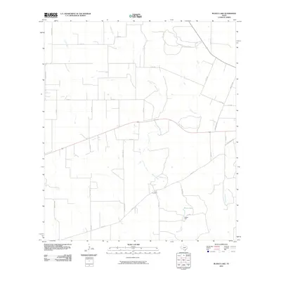
2010 Map of Blanco Lake
USGS Topo · Published 2010About this map
Blanco Creek and its seasonal tributaries define this Uvalde County landscape, where the drainage network creates a lattice across the brush country north of Sabinal. The hydrology is anchored by Blanco Lake in the southeast, a significant water body managed by Reagan Dam. This system of creeks, including Dinner Creek, Little Blanco Creek, and Nolton Creek, dictates the placement of the area's rural road network, which transitions from state-maintained routes like Ranch Rd 1049 to numerous county roads.
Find a feature on this map
29 named features on this map. Tap any name to fly to it.
Don’t see what you’re looking for? This feature index may not catch every label — zoom into the map to look around manually.
Map Details
Editions of this 2010 Blanco Lake Map
This is the sole edition of this map. No revisions or reprints were ever made.
Other maps of this area

1898 · Uvalde
USGS Topo · 1:125,000

1899 · Uvalde
USGS Topo · 1:125,000

1928 · Frio Town
USGS Topo · 1:62,500

1954 · San Antonio
USGS Topo · 1:250,000

1956 · Sabinal
USGS Topo · 1:62,500

1957 · San Antonio
USGS Topo · 1:250,000

1960 · Concan
USGS Topo · 1:24,000

1969 · Comanche Waterhole
USGS Topo · 1:24,000
1969 · Trio
USGS Topo · 1:24,000
1970 · Irishman Hill
USGS Topo · 1:24,000