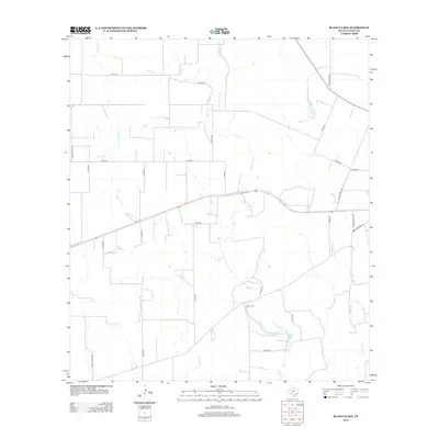
2012 Map of Blanco Lake
USGS Topo · Published 2012About this map
Blanco Lake lies at the heart of this rural Uvalde County landscape, where a network of ephemeral waterways and ranch roads defines the terrain. The hydrology is dominated by the winding paths of Blanco Cr, Dinner Cr, and Nolton Cr, which converge near the lake in the southern portion of the quadrangle. This area, surveyed in the early 21st century, remains primarily pastoral, characterized by vast tracts of land accessed by a grid of county roads and state ranch roads. Local history is anchored by the Wish Cem, located just north of the lake along Co RD-301. The map also captures the path of Lower Sabinal Rd and Ranch Road 1023 in the eastern section, illustrating the persistent transportation corridors that have served this South Texas ranching country for generations.
Find a feature on this map
28 named features on this map. Tap any name to fly to it.
Don’t see what you’re looking for? This feature index may not catch every label — zoom into the map to look around manually.
Map Details
Editions of this 2012 Blanco Lake Map
This is the sole edition of this map. No revisions or reprints were ever made.
Other maps of this area

1898 · Uvalde
USGS Topo · 1:125,000

1899 · Uvalde
USGS Topo · 1:125,000

1928 · Frio Town
USGS Topo · 1:62,500

1954 · San Antonio
USGS Topo · 1:250,000

1956 · Sabinal
USGS Topo · 1:62,500

1957 · San Antonio
USGS Topo · 1:250,000

1960 · Concan
USGS Topo · 1:24,000

1969 · Comanche Waterhole
USGS Topo · 1:24,000
1969 · Trio
USGS Topo · 1:24,000
1970 · Irishman Hill
USGS Topo · 1:24,000