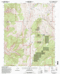
1994 Map of Blanco Mountain
USGS Topo · Published 1997About this map
Ancient Bristlecone Pine Forest and the high-elevation slopes of the Inyo Mountains dominate this mid-1990s survey. This specialized landscape, protected within the Inyo National Forest, includes the famed Schulman Grove, home to some of the world's oldest living organisms. The terrain is marked by significant elevation changes, from the depths of Silver Canyon and Wyman Creek to the summits of Blanco Mtn and Campito Mountain. Scientific research is a prominent feature of the area, anchored by the White Mountain Research Station Crooked Creek Laboratory. Evidence of historic extraction persists through the Mexican Mine and various unnamed prospects scattered near Big Prospector Meadow and Reed Flat. The map also captures the political geography where the boundary between Mono and Inyo counties crosses over County Line Hill.
Find a feature on this map
38 named features on this map. Tap any name to fly to it.
Don’t see what you’re looking for? This feature index may not catch every label — zoom into the map to look around manually.
Map Details
Editions of this 1994 Blanco Mountain Map
This is the sole edition of this map. No revisions or reprints were ever made.
Other maps of this area

1913 · Bishop
USGS Topo · 1:125,000

1917 · White Mountain
USGS Topo · 1:125,000

1947 · Mariposa
USGS Topo · 1:250,000

1948 · Mariposa
USGS Topo · 1:250,000

1949 · Bishop
USGS Topo · 1:62,500

1951 · Bishop
USGS Topo · 1:62,500

1951 · Blanco Mountain
USGS Topo · 1:62,500

1957 · Mariposa
USGS Topo · 1:250,000

1962 · Mt. Barcroft
USGS Topo · 1:62,500

1962 · White Mtn. Peak
USGS Topo · 1:62,500