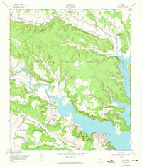
1958 Map of Bland
USGS Topo · Published 1974About this map
The Fort Hood Military Reservation dominates this central Texas landscape, where military training grounds meet the rising waters of the Leon River valley. Established in the late 1950s, the map reveals the complex intersection of federal land use and local geography along the Coryell Co Bell Co line. Significant terrain features like the Owl Creek Mountains, Sparta Mountain, and Union Hill overlook the expanding reaches of Belton Lake, which floods the eastern portions of the quadrangle. Small settlements like Bland and Cold Springs remain as anchors of the earlier ranching era, while the County Line Community Ch serves as a social landmark near the northern boundary. The intricate drainage system, including Cowhouse Creek and the curiously named Metheglin Creek, illustrates the rugged topography that necessitated the filtration and infrastructure developments seen at the Filtration Plant.
Find a feature on this map
25 named features on this map. Tap any name to fly to it.
Don’t see what you’re looking for? This feature index may not catch every label — zoom into the map to look around manually.
Map Details
Editions of this 1958 Bland Map
Other maps of this area

1892 · Temple
USGS Topo · 1:125,000

1894 · Gatesville
USGS Topo · 1:125,000

1924 · Gatesville 4-d
USGS Topo · 1:48,000

1924 · Gatesville 4-a
USGS Topo · 1:48,000

1924 · Temple 2-C
USGS Topo · 1:48,000

1924 · Temple 3-C
USGS Topo · 1:48,000

1924 · Temple 3-B
USGS Topo · 1:48,000

1930 · Killeen
USGS Topo · 1:62,500

1931 · Mc Gregor
USGS Topo · 1:62,500

1931 · Belton
USGS Topo · 1:62,500