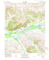
1977 Map of Blandville
USGS Topo · Published 1977About this map
Blandville sits atop the high ground of the Jackson Purchase region in this late 1970s revision, overlooking the expansive wetlands of the Mayfield Creek basin. This topographic study reveals a landscape defined by the drainage patterns of the West Fork and Hurricane Creek, where the floodplain is broken by features like the St Arbor Slough. The rural character of western Kentucky is evident in the scattered settlements of Cunningham, New York, and Garner, which are connected by a network of local roads and family-named landmarks.
Find a feature on this map
31 named features on this map. Tap any name to fly to it.
Don’t see what you’re looking for? This feature index may not catch every label — zoom into the map to look around manually.
Map Details
Editions of this 1977 Blandville Map
This is the sole edition of this map. No revisions or reprints were ever made.
Other maps of this area

1928 · La Center
USGS Topo · 1:62,500

1931 · Cairo
USGS Topo · 1:62,500

1932 · La Center
USGS Topo · 1:62,500

1933 · Cairo
USGS Topo · 1:62,500

1939 · Wickliffe
USGS Topo · 1:62,500

1939 · Cairo
USGS Topo · 1:62,500

1949 · Paducah
USGS Topo · 1:250,000

1950 · Paducah
USGS Topo · 1:250,000

1951 · Blandville
USGS Topo · 1:24,000

1951 · Arlington
USGS Topo · 1:24,000