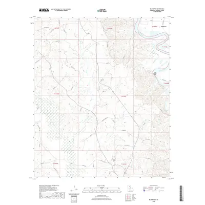
2018 Map of Blankston
USGS Topo · Published 2018About this map
The Ouachita River defines the northeastern boundary of this Caldwell Parish landscape, carving a wide path past Lone Grave Bluff and the small settlement of Blankston. The terrain is characterized by a complex network of drainage basins, where waterways like Bills Cr, Castor Cr, and Lost Cr weave through the timbered bottomlands and low hills. This 2018 survey reveals a rural infrastructure built around old family and community roads, such as Ester Rd and Honeycutt Rd, which connect isolated homesteads and local landmarks. Genealogists will find interest in the documented locations of Fellowship Cem and Mount Pleasant Cem, which serve as quiet markers of the area's long-standing community roots. To the east, the presence of Horseshoe Lake and Upper Lone Grave Bayou highlights the ever-shifting hydrology of the river basin.
Find a feature on this map
56 named features on this map. Tap any name to fly to it.
Don’t see what you’re looking for? This feature index may not catch every label — zoom into the map to look around manually.
Map Details
Editions of this 2018 Blankston Map
This is the sole edition of this map. No revisions or reprints were ever made.
Other maps of this area

1940 · Monroe
USGS Topo · 1:62,500

1940 · Columbia
USGS Topo · 1:62,500

1953 · Chatham
USGS Topo · 1:62,500

1954 · Sikes
USGS Topo · 1:62,500

1955 · Shreveport
USGS Topo · 1:250,000

1956 · Shreveport
USGS Topo · 1:250,000

1957 · Columbia
USGS Topo · 1:62,500

1957 · Monroe South
USGS Topo · 1:62,500

1982 · Chatham SE
USGS Topo · 1:24,000
1982 · Luna
USGS Topo · 1:24,000