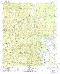
1982 Map of Luna
USGS Topo · Published 1982About this map
The Ouachita River meanders through the eastern edge of this quadrangle, creating complex waterways like Coco Bend and the Cutoff Bayou. The landscape is characterized by numerous low-lying wetlands, including the expansive Watson Brake, Alligator Brake, and Prairion Brake. These swampy features alternate with higher ground where settlements like Luna and the Pinecrest Sch are established. To the south, the Vixen Gas Field indicates the region's industrial connection to natural resources, while the presence of a Fish Hatchery and several cemeteries, such as St Pauls Cem and Pine Grove Cem, suggest a well-established rural community.
Find a feature on this map
55 named features on this map. Tap any name to fly to it.
Don’t see what you’re looking for? This feature index may not catch every label — zoom into the map to look around manually.
Map Details
Editions of this 1982 Luna Map
This is the sole edition of this map. No revisions or reprints were ever made.
Other maps of this area

1940 · Monroe
USGS Topo · 1:62,500

1940 · Columbia
USGS Topo · 1:62,500

1953 · Chatham
USGS Topo · 1:62,500

1954 · Sikes
USGS Topo · 1:62,500

1955 · Shreveport
USGS Topo · 1:250,000

1956 · Shreveport
USGS Topo · 1:250,000

1957 · Columbia
USGS Topo · 1:62,500

1957 · West Monroe South
USGS Topo · 1:24,000

1957 · Monroe South
USGS Topo · 1:24,000

1957 · Monroe South
USGS Topo · 1:62,500