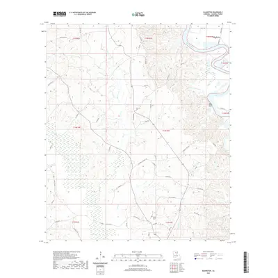
2020 Map of Blankston
USGS Topo · Published 2020About this map
The Ouachita River defines the eastern boundary of this Louisiana landscape, winding past the notable Lone Grave Bluff and the nearby Upper Lone Grave Bayou. This Caldwell Parish region is marked by a complex network of waterways, including Castor Creek, Bills Creek, and Richland Creek, which drain the undulating terrain. The small community of Blankston sits in the northeast corner, while the interior is dotted with local landmarks such as Fellowship Cemetery and Mount Pleasant Cemetery. The presence of numerous secondary roads like State Route 846, Riverview Ranch Road, and Lock & Dam Road suggests a rural economy tied to the river and the surrounding wetlands, which include the distinctive Horseshoe Lake.
Find a feature on this map
57 named features on this map. Tap any name to fly to it.
Don’t see what you’re looking for? This feature index may not catch every label — zoom into the map to look around manually.
Map Details
Editions of this 2020 Blankston Map
This is the sole edition of this map. No revisions or reprints were ever made.
Other maps of this area

1940 · Monroe
USGS Topo · 1:62,500

1940 · Columbia
USGS Topo · 1:62,500

1953 · Chatham
USGS Topo · 1:62,500

1954 · Sikes
USGS Topo · 1:62,500

1955 · Shreveport
USGS Topo · 1:250,000

1956 · Shreveport
USGS Topo · 1:250,000

1957 · Columbia
USGS Topo · 1:62,500

1957 · Monroe South
USGS Topo · 1:62,500

1982 · Chatham SE
USGS Topo · 1:24,000
1982 · Luna
USGS Topo · 1:24,000